

Duluth Harbor Ship Schedule
This lakeside drive, Scenic 61, is part of the original Highway 61, following the 1899 wagon trail about 20 miles from Brighton Beach to the entrance to Two Harbors. It offers overlooks, access to Lake Superior, shops, restaurants and lodging. Mostly it gives the flavor of what Highway 61 was like back in the day.
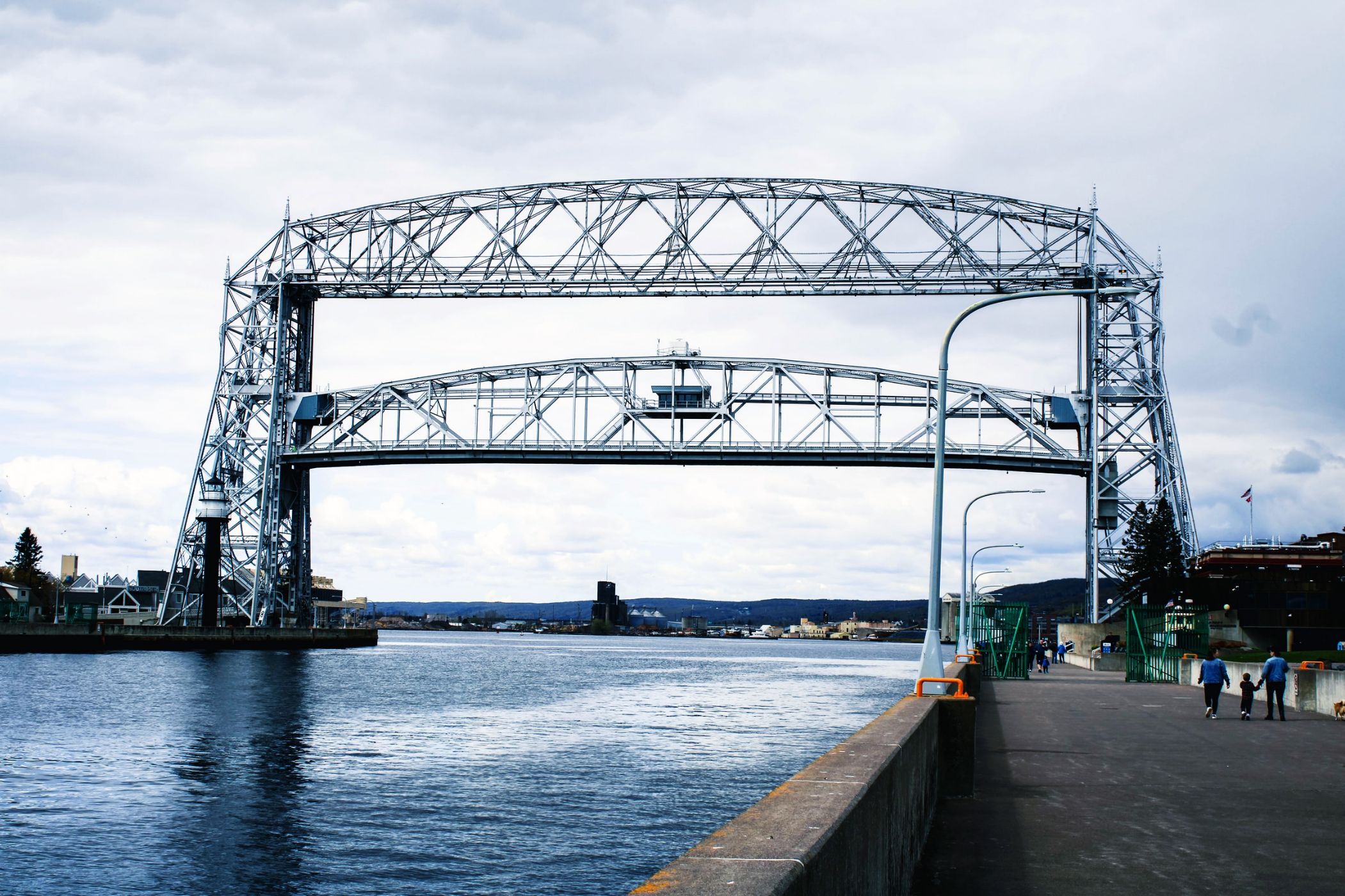
The gargantuan counterweights slowly descend, raising the 900-ton span of the Aerial Lift Bridge, nearly 140 feet in the air. That allows the 1000-footers (ore boats carrying taconite pellets) and salties (ocean-bound ships) to pass into the harbor.
The canal was excavated in 1871 and is a deceptive 300 feet wide and 1,650 feet long. The first aerial transfer was erected in 1905 and modernized in 1929 to what you see today. It can rise to its full height in 55 seconds.
Just up the road from Two Harbors is the tiny burg, Castle Danger, whose moniker has conjured a number of theories, including that it was named after a boat, the Castle, that ran aground nearby or that the shoreline cliffs looked a bit castlelike, If you squint a bit. In just the right light. Whatever the namesake, this little burg is a nice base for hiking the Superior Hiking Trail, riding the Gitchi Gami Trail and rambling about the state park at Gooseberry Falls MN.
The Lake Superior Maritime Museum houses actual-size replicas of a ship cabin, pilothouse, and massive steam engine. Exhibits and displays include several scale ship models. They list and announce all ship arrivals and departures, too. It’s free!
Ah, the most visited spot on the shore – Split Rock Lighthouse. This century-old light sits atop a 130-foot cliff at Superior’s edge, once a beacon of safety for passing ships, now an icon for travelers. Born on the backs of the 29 ships damaged during the infamous storm of November 1905, the light was in use until 1969 when it and the adjacent scenic wayside became a state park.
Choose the ‘Two Harbors Turn’ and ride the rails from downtown Duluth to the waterfront in Two Harbors. Hop off, have lunch, shop and board for the return trip.
Operates summer weekend leaving at 10 am and returning late afternoon.
Enjoy the eclectic mix of shops and restaurants, then stop by the cemetery and pay your respects to legendary North Shore mail carrier John Beargrease.
Spacious slips for daily or seasonal rental, a picnic area, amenities in the marina shop, a short hiking path and a top-notch view of ships being loaded with taconite at Cliffs Natural Resources dock. The Silver Bay Marina plays host to the annual Salmon Classic fishing contest, too.
Grand Marais is a very walkable town. Park out on Artist Point, follow the beach around the harbor, then take the covered bridge into the campground, wind your way through, skirting Lake Superior and conclude with a climb to Sweetheart’s Bluff. After an invigorating downhill return, you can walk the 3-mile round-trip paved Gitchi Gami trail west out of town to the cemetery and distant lake views before returning the same route.
Downtown Grand Marais is a three-block long strip centered around Harbor Park, a breezy sitting and gathering area leading to the cobblestone beach of the harbor. Shops, restaurants, museums, and galleries are clustered along Wisconsin Street and the side avenues stretching to and just inland from Highway 61.
Browse gifts, books, treats, spirits, coffee, necessities and sundries plus a small café. Located on the north and south side of the highway in this quarter-mile stretch.
At the crossroads of MN Hwy 1, the Little Marais Rd and the Cramer Rd, set in the picturesque valley behind the Sawtooth range is Finland Minnesota. A couple of restaurants, a couple of state parks, a couple of backroads, a couple of attractions. This is what a number of the small shoreline villages were like 25 years ago.
This is the only place on the entire Lake Superior shoreline where you will find a black beach. So it’s worth the stop. This calm slice of shoreline gets its name from the taconite tailings [crushed rock] that make up the beach. Taconite is a hard rock that has low-grade iron ore and is found throughout northern Minnesota, especially on the Iron Range. When a nearby plant, crushed the rock to remove the iron, the remains were these tailings. So, prior to the 1950s this was a pebble beach. The plant was closed in the 1970s leaving behind this reminder.
There are different vantage points, so be sure to explore. It’s picturesque and a good spot to takes photos.Picnic tables and outhouses provided. This is an easy stop to make as it is just northeast of the stoplight on Highway 61 at Silver Bay. It’s a short mile down Lakeview Drive to the main parking.
Drive right up to this expansive beach, Iona’s Beach Scientific & Natural Area, which is bookended by cliffs, rhyolite, and bedrock to the north and basalt to the south. Nor’easters work away at the northern cliff, breaking off shards of the pink rhyolite and washing them down shore. Once home to Twin Points Resort, the area is named after longtime owner Iona Lind.
Palisade Head is a lakeside cliff with a stellar sweeping outlook over Lake Superior and up and down its shoreline. In the summer, drive to the top along a curvy tree-shadowed barely-two-lane road with limited parking and an occasional blueberry bush at the top. In winter, you can hike up the unplowed road. Stop at the Tettegouche State Park office for a permit if you wish to climb [gasp!] Palisade.
Take a leg-stretcher along the 1-mile interpretive nature trail that departs from the parking area and includes a stop at Sugarloaf Cove on Lake Superior. The Interpretive Center has exhibits and artifacts from early logging operations in the area. See historic logging operation artifacts and take part in nature programs. The site is also a Scientific and Natural Area, home to unque geological and plant specimens.
The name sugarloaf comes from the craggy rocks jutting out of Lake Superior near the shore. Settlers purchased white sugar in cones aka sugarloaves, and the rocks in the cove reminded them of a partially used sugarloaf.
From 1929 roadhouse, to manifestations as a general store gas station, post office, and sausage market, the Cross River Heritage Center now houses historical exhibits, a gift shop and visitor information, and many wonderful photos and details of logging in the area. One of the original Stickney Inn rooms has been preserved and is open to the public, too.
Amazing river gorges that start a few feet inland from the highway, waterfalls, two foot-bridges, hiking, a cobblestone river mouth, camping and hiking. Hike a short way upriver to the amazing gorges, then return south of the highway and walk across the foot-bridge. During spring runoff or after rainy days, the river spray will mist you. Back in the day, this was the only river without a [sand] bar at the mouth, hence the name, Temperance.
This perennial favorite, the Oberg Mountain Loop, starts off a short spur from the parking area and climbs at an angle up to western views down the shore, then panoramic Lake Superior views to the south, then northeast view up the shoreline, and finally northern views over Oberg Lake and the amazing maple-covered hillsides to the north. The trail meanders under maple and birch canopies, over bedrock slabs, and can be steep at times. The loop is 2.25 miles in total.
Share your sentiments under the canopy of the covered bridge over the Poplar River. While you’re choosing the ideal photo spot, check to see if anyone is fishing the river mouth. The bridge is part of Lutsen Lodge and is open to everyone.
Lutsen Mountains, the Midwest’s largest and tallest ski area, offers alpine skiers and snowboarders 95 sweeping runs over four mountains. Non-skiers can enjoy slopeside views and amenities at two chalets. Spring, summer, and autumn visitors can hike, bike, ride the gondola and alpine slide, and dine at the chalets.
Wolf Ridge, which sits on a spectacular 2000-acre site above Lake Superior, is internationally know for its top-notch outdoor learning and adventure programs. They offer multi-day family camps, summer camps, wilderness adventures, and grandparent/grandchild Road Scholars in addition to hosting school groups year-round. For a shorter experience, reserve a naturalist-guided half-day Split Rock Kayak Tour or drop by to explore the trails, overlooks, and educational displays.
MN Scientific and Natural Areas (SNA) protect the last remaining habitat for Minnesota’s rarest plants and animals. Recreation is limited to protect this habitat and natural diversity.
Vivid orange crustose lichen drapes the bedrock shores and crowns the cliffs of this site near Grand Marais, located within Cascade River State Park. Butterwort Cliffs SNA consists of a narrow, 43-acre strip of land between Highway 61 and Lake Superior, with wet rocky shore and dry bedrock shore communities, fringed by aspen-birch forest.
Butterwort, for which this SNA is named, is an insectivorous plant that grows in fragile mats. Its leaves are equipped with two glands: one that secretes a sticky solution that traps insects and the other, the enzymes to digest them. It is recognized by its blue-purple flowers appearing singly on slender stems arising from a basal rosette of yellow-green leaves, often found clustered in overlapping patches. Look closely, you’ll likely see insects that have met their match.
Heading northeast, just past Thomsonite Beach, Highway 61 curves left, revealing picturesque Good Harbor Bay, Seagull Rock, and, in the distance, Grand Marais. Use the pull off to admire the view and take photos. A quarter mile farther is Cut Face Creek Wayside, a nice spot for a picnic, an agate search, and skipping stones.
The 35-foot fishing tug Neegee, or “friend” in Ojibwe, was completed in 1936 in Grand Marais and used in Lake Superior through the 1950s. To learn about commercial fishing in that era, take the self-guided tour of the boat and fish house.
North House Folk School engages in promoting and preserving the knowledge, skills, crafts and stories of the past and present. Classes, courses and programs are student-based and range from blacksmithing to woodworking, bread baking to weaving, timber-framing to basketry.
The campus offers a gift store, weekly tours, many events and programs and a complete catalog of courses. All on the shores of Lake Superior.
The Gunflint Trail climbs 600 feet in the first few miles to a maple ridge line. At the top is Pincushion Mountain Overlook, a parking area with 180° views of Lake Superior. For the full circle view, make the 4-mile roundtrip hike to the top of Pincushion. This recreation area is criss-crossed with single track bike trails, hiking trails, cross-country and snowshoe trails. It is conveniently located three mile from Grand Marais.
Privately maintained wildflower sanctuary established in 1958. Features include flowers, woods, ferns, river bank, pollinator rain garden and 100′ stairway to the ridge overlooking the river. Almost a mile of chipped trails, and 2,000 feet of frontage on the Devil Track River.
Off street parking and many Native flowers blooming from April to September.
Part of Kitchi-Gami park; Brighton Beach is perfect for skipping stones, agate-hunting, ship-watching, wading, picnicking and lollygagging. Features summer-use restrooms, picnic tables and grills. Brighton Beach starts just past the little blue tourist info center and runs 0.8 miles to Scenic 61/Congdon Blvd.
Note North Shore beaches are pebble or cobblestone; for sand, head to Park Point In Duluth.